Feu de Saint-Pol
386X+6Q Dunkirk, France
Name and Location
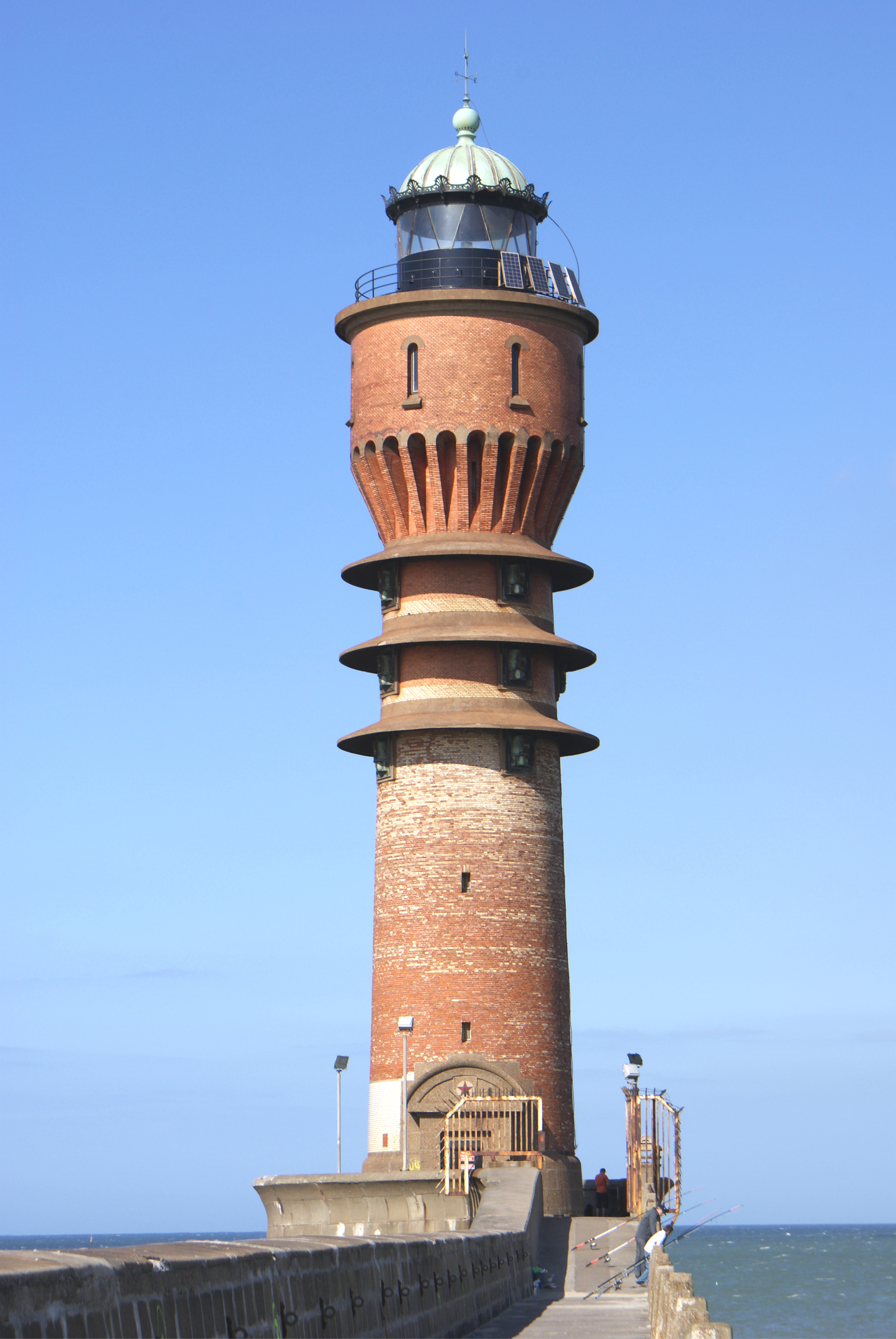
Feu de Saint-Pol, also known as Saint-Pol Lighthouse, is a historic harbour light located at Dunkirk (Dunkerque), in the Nord department of Hauts-de-France, northern France. The address is Jetée de Saint-Pol, 59140 Dunkerque, France, with coordinates 51° 03′ 38.0″ N, 2° 20′ 57.1″ E (decimal 51.0605655, 2.3494198).
Construction and History
Feu de Saint-Pol is a historic monument listed by the French Ministry of Culture on December 31, 1999. The exact construction date is not available in the record, but it was erected as part of Dunkirk's harbour improvements to guide shipping safely in and out of the port.
Architecture and Materials
The lighthouse has a cylindrical tower rising directly from the pier, standing at a height of 36 meters (tower height) with a focal plane of 35 meters above sea level. The materials used are not specified in available sources, but local breakwater lights of similar era are often made of masonry or cast-iron construction.
Light and Navigation
The light is green and has a flashing group pattern reported as "1 + 1 + 1 + 3" flashes, synchronized with the neighbouring light NGA 8996. The period is 6 seconds (total cycle), with a range of 10 nautical miles. It serves as an active aid to navigation and is maintained by French maritime authorities.
Accessibility and Visiting
The west jetty is open to pedestrians, but the interior of the lighthouse is not open to visitors. There are no visitor facilities on site, and guided tours are not available. However, the exterior of the light can be accessed on foot, offering panoramic views of the Dunkirk breakwaters, the North Sea horizon, and passing commercial traffic.
Notable Views and Landscape
From the pier deck, the lighthouse offers stunning views of the Dunkirk breakwaters, the North Sea horizon, and passing commercial traffic. The surrounding area features a waterfront promenade, the Musée Portuaire (Harbour Museum), and Fort des Dunes, all within easy walking distance.
Anecdotes and Folklore
Feu de Saint-Pol played a strategic role during both World Wars, with its presence contributing to the port's defence and evacuation operations. Its flash rhythm is carefully coordinated with the east-pier light (NGA 8996) to provide clear channel guidance.
Technical and Operational Details
The lighthouse is an active aid to navigation, fully automated, and does not have a keeper duty. It acts as a visual beacon only, without AIS or radar installations specifically associated. The Admiralty Chart reference is A1118; NGA 114-8992; ALADIN 5900032.
Further Information
For further reading and references, please visit the French Ministry of Culture's Base Mérimée entry PA59000049, the NGA List of Lights, volume covering the English Channel (no. 114-8992), the Admiralty List of Lights & Fog Signals (A1118), Wikimedia Commons: https://commons.wikimedia.org/wiki/File:Spol.jpg, and the French Wiki article (in French): fr:Feu de Saint-Pol.
Details
| Name | Feu de Saint-Pol |
|---|---|
| City | Dunkerque |
| Country | France |
| Coordinates | 51.0605655, 2.3494198 |
| Events | role in wartime during both World Wars |
| Historic significance | Historic monument listing: Inscribed by the French Ministry of Culture on 31 December 1999. |
| Stories | Synchronisation: Its flash rhythm is carefully coordinated with the east-pier light |
| Architectural style | Cylindrical tower rising directly from the pier |
| Construction material | masonry, cast-iron |
| Focal height | 35 |
| Tower height | 36 |
| Heritage status | true |
| Access description | by foot from the pier deck |
| Accessible | true |
| Landscape type | coastal |
| View description | panoramic views of the Dunkirk breakwaters, the North Sea horizon, and passing commercial traffic |
| Guided tours | false |
| Nearby attractions | Dunkirk's waterfront promenade, Musée Portuaire (Harbour Museum), Fort des Dunes |
| Light characteristic | Flashing group light, pattern reported as ‘1 + 1 + 1 + 3’ flashes |
| Light range | 10 |
| Automated | true |